Length 8.8 km (5.5 miles), terrain has a hill, rising 173 meters, elevation is high: 2500 meters (8000 feet)!
For more running routes, see Route List
Here's a route that I've included just for the fun of it. It is one of the most beautiful trails in the world, but will probably not be run very often. At 2500 meters (8000 feet) in elevation, you need to be well-acclimatized to the height if you want to try it.
I'm a flat-lands runner, and I really felt the elevation, getting winded quickly and often when I was in Bryce last week. So I just hiked this trail. But for anyone who is used to running in high altitudes, here is a running trail for you.
 |
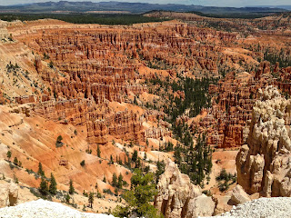
| The Bryce Canyon hoodoos |
Another nice thing about this route is that a free park shuttle-bus service follows the cliff, and you can get on- or off at the main viewpoints. So if you find out that you aren't in as good a shape as you thought, you can just hop on the next bus when it comes. (They stop at Sunrise Point, Sunset Point, Inspiration Point and Bryce Point).
We'll start this route right near the park lodge and northern campground, at Sunrise Point. We'll then run south along the rim to Bryce Point, then run back the same direction.
 |
| Sunrise Point |
Turn south and run along the rim trail, sometimes just sand and rock, other times (at the lookout points) paved. You can already see Sunset Point ahead of you, with its railings along the rim.
 |
| Dead tree along the rim |
 |
| Looking back towards Sunset Point |
At the 2-km marker, you reach the next viewpoint, Inspiration Point. Soon, the trail will level-out again and begin going downhill until the turn-around point.
You are now running past white sandstone cliffs, with some big caves and windows in them.
 |
| From Bryce Point |
Now turn around and head back to Sunrise Point.
No comments:
Post a Comment