Length 8 km (5 miles), terrain: hilly, gain 113 meters
Madrid running routes:
Madrid Old Town Sights route
Madrid Parque del Oeste route
Madrid Parque del Retiro route
Madrid Casa de Campo trail run
Madrid Rio Manzanares route
Madrid Cañadas trail run
For more running routes, see Route List.
NOTE: In the summer, Madrid is hot, normally around 35C degrees or even higher. Mornings are coolest and the best time to run, but even on hot evenings it can be doable, because often a strong breeze comes along in the evening, making things feel cooler.
The north side of Madrid is known for its modern suburbs and high-tech office parks. Lots of international companies have set up shop there, so you might end up hanging out there yourself.
But running past office buildings and malls might not be what you were hoping for in your time in Madrid. That's where this route comes in: exploring a section of Spanish countryside, with its rolling hills full of local plants and animals, grazing sheep, little farmsteads. A real trail run, and all that right on the edge of the suburbs.
 |
| Running group just leaving the cañadas |
The area is known for its little vineyards and orchards. Nowadays it is mainly used as meadows for sheep and horses, criss-crossed by dusty foot trails, the cañadas. This route follows those cañadas, historic cattle-drove roads through the hilly grasslands.
NOTE: The route is not well-marked. We'll follow the yellow arrows for the Camino de Madrid pilgrimage trail for the first few kilometers. But after that, there are no further waymarkers or road signs out along the cañadas. But if you watch the direction of the sun, and on the hill crests you look for the 2.5-km high peaks of the Sierra de Guadarrama mountains to the north and the skyscrapers around Chamartin train station to the south, you'll find good orientation points.
 |
| Head this way from the Metro station |
Now, head north on the sidewalk through the narrow square from the Metro station until it ends a couple of blocks later at a wall, across Av. del Santuario de Valverde. There is a cemetery behind the wall.
 |
| The cross along the Camino de la Cañada |
Follow the trail as it heads downhill, past a cross marking the beginning of the Camino De Madrid pilgrimage trail towards Santiago de Compostela.
Mountains line the horizon to the north.
The trail seems to end at a popular red-painted asphalt track for bikers and pedestrians. But you need to continue straight down the steep embankment towards the railway and the M40 freeway ahead in the valley.
 |
| The tunnel under the freeway |
When you come out on the other side, you are suddenly in another world: little farmsteads and meadows along hillsides, with rutted, dusty trails winding between them. Follow the yellow arrows for the Camino De Madrid trail.
After 100 meters, at a fenced field, take the right-hand trail as it splits, which is still called Camino de la Cañada. There is a yellow arrow pointing the way. We'll later return from the left-hand trail.
 |
| Waymarker for the Camino de Madrid |
Head gradually uphill towards the rolling hilltop meadows, amid grazing sheep. A couple of other trails will merge from the right side.
Enjoy the beautiful stretches of Spanish plant- and animal-life. The fields are full of pale thistles that look like miniature Atomiums, broom bushes, grasses, thorn trees. I saw a harmless snake, rabbits, hawks, doves. Listen to the locusts chirping. I saw a shepherd with his border collie watching over a big herd of grazing sheep.
 |
| Rabbit holes in the arroyo |
At the 3-kilometer mark, you'll see a valley beginning to your left side, stretching to the southwest. That is the Arroyo de Valdecervero. Turn left onto the trail that heads down into the valley. At first, there is no real stream-bed in the valley, but as you continue, you can see it form. Follow it as the gulch gradually gets deeper, full of raspberries and rabbit holes.
 |
| Along the arroyo |
Just before the 5-kilometer mark, at the first major crossroads with another wide trail, look for a little fenced farmstead off to the left, up the hill to the south. Turn left there.
NOTE: Don't worry, you can take any turnoff to the left to get back, actually.
 |
| Turn and follow this trail up past the fenced-in farm |
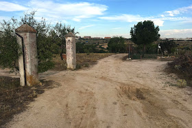
You'll then pass a fenced-in orchard on your right side, as well as some old cement gateposts on the left. Just continue downhill as you pass the 6-km mark.
 |
| The gateposts and orchard: keep going straight! |
You'll also see a line of trees down in the valley: another arroyo, the Arroyo del Monte, but this one is lusher, supporting a thick growth of trees and other plants.
Turn left at the arroyo and follow the path eastwards. You can clearly hear the nearby freeway to the right. The path will wind along the arroyo for a while.
 |
| Along the Arroyo del Monte |
No comments:
Post a Comment