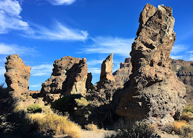
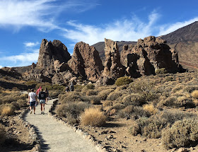
Length 3.5 km (2.2 miles), terrain: rocky, one steep section, gain 211 meters
NOTE: If you like this short route, you might want to add-on one of the others that begin at the Parador.
The most spectacular place on the Canary island of Tenerifa is El Teide, the huge volcano dominating the island from every viewpoint. So you're almost sure to be drawn upwards to this fascinating stone wilderness, with other-worldly rock formations, lava flows, yellow sulphur vents and scrubby desert plants.
 |
| View over the caldera from the peak of El Teide |
Our route in this post, the Roques de García, are a group of spectacular rocks down in the main caldera, or volcanic cone valley. The valley stretches out at the foot of the Teide peak, which is a much higher cone than the big one below it. The peak rises to over 3,700 meters, Spain's tallest mountain. The surrounding valley, with los Roques, is just over 2,000 meters high.
 |
| Some lava chimneys along the Los Roques trail |
This trail circles los Roques, starting near the park lodge, the Parador. The lodge has parking, and -- even more important -- refreshments for later. The lodge is a meeting place for hikers and bicyclists from all over the island.
 |
| Looking back at the Parador and south rim from the trail |
A paved foot-trail connects also the Parador to the nearby Roques de García trail, across the main park road. A parking area there means a lot of visitors stop at the base of Roques de García. But don't despair, after just a few minutes on the hiking trail itself, you'll hardly see anyone else.
 |
| Start of the trail at Los Roques |
At the far end of the parking area, the rocks begin. There is a scenic lookout there, the Mirador de la Ruleta.
 |
| View towards El Teide from the trail |
Now just head up the trail, with the rocks to your left side. The way is fairly flat here.
 |
| Formations along the trail |
Los Roques look like a steep, crumbling ridge, with rubble lying at the base of each rock. Between the stone towers, El Teide rises up along the northern horizon.
At about 700 yards, you'll pass a lava flow that came down the mountain from the north.
Past the first kilometer mark, another trail leads off upwards towards the second highest peak, the Pico Viejo.
 |
| Pico Viejo as seen from a high trail, with island of La Gomera in background |
The trail will continue downwards to the south, towards a solitary stone tower, called the Cathedral.
 |
| The Cathedral in shadows, on the right, as seen from higher rocks |
You'll now pass right below the Cathedral, standing alone to the west of the others. At its base the trail now heads uphill fairly steeply, heading back to the Mirador de la Ruleta, passing the Cathedral.
 |
| Way-markers at the base of the Cathedral. Keep left here, then uphill! |
Once at the top, it's just a short walk back to the Parador to grab some pizza and a cold drink, and sit on their terrace for a view of this amazing national park!
 |
| Back at the Parador, with view of Los Roques and El Teide |
No comments:
Post a Comment